Return to Hobie.com
Hobie Forums
It is currently Wed Apr 24, 2024 2:41 am

All times are UTC - 8 hours [ DST ]


Post new topic Reply to topic  [ 7 posts ] 
Author Message
PostPosted: Wed Apr 04, 2012 8:12 am 
Offline
Site Rank - Deck Hand

Joined: Thu Feb 09, 2012 9:20 pm
Posts: 16
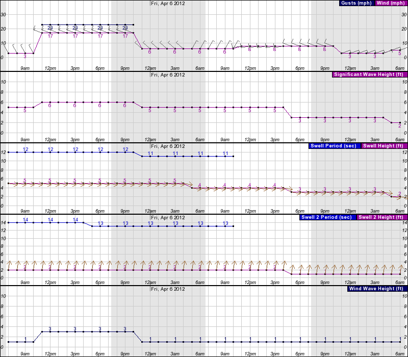
Hi everyone, I am trying to accurately read marine forecasts but I don't fully understand them. I guess I need pictures and a weather for dummies book. I use the website weather.forecast.gov and have included the report for this Thursday and Friday for the Oxnard / Ventura area. Don't worry, I can guess that these conditions suck for an A.I. and would never attempt this. Can someone explain what all the terms mean (in lay terms?) And perhaps post pics. The time I was looking at was Thursday 11:00am - 5:00pm

Image


Top
 Profile  
 
PostPosted: Wed Apr 04, 2012 9:15 am 
Offline
Site Rank - Admiral

Joined: Sun Aug 01, 2010 5:03 pm
Posts: 168
Location: Va Beach, Virginia
Trapper,

try weather.com.http://mw.weather.com/tenday/USCA0819?family=webkit


Top
 Profile  
 
PostPosted: Thu Apr 05, 2012 1:17 pm 
Offline
Site Rank - Deck Hand

Joined: Fri Sep 16, 2011 6:22 pm
Posts: 15
Location: Sassafras River, Maryland
I'd like to see the original site and that data. I keyed in the site, but didn't get any hits. Can you post the full site name? Normally there's a key somewhere on the site explaining what the symbols mean.

Meanwhile, there are many sites out there for marine forecasts. Here's a text site I use for the Chesapeake Bay: http://weather.noaa.gov/pub/data/raw/fz ... wf.lwx.txt

If you just use http://weather.noaa.gov there's a link for marine weather and you can enter in your area of interest.

Weather.com is a good one, as is wunderground

Jeff


Top
 Profile  
 
PostPosted: Thu Apr 05, 2012 6:28 pm 
Offline
Site Rank - Admiral

Joined: Mon May 02, 2011 8:48 am
Posts: 159
Location: Southwest Calif.
This site might be the easiest for you.
http://forecast.weather.gov/MapClick.php?map.x=226&map.y=131&minlon=-121.29&maxlon=-117.61&minlat=32.65&maxlat=35.81&mapwidth=354&site=lox&zmx=1&zmy=1

_________________
Image


Top
 Profile  
 
PostPosted: Sun Apr 08, 2012 9:03 am 
Offline
Site Rank - Admiral

Joined: Mon Oct 03, 2011 9:10 am
Posts: 151
Location: Tampa Bay, FL
www.windfinder.com

_________________
2019 Hobie Outback Slate Blue
2018 Hobie Compass Seagrass Green
2012 Hobie Pro Angler w/MD180 Papaya Orange

ex 2012 Hobie Tandem Island
ex 2011 Hobie Pro Angler
ex 2011 Hobie Adventure Island
ex 2010 Hobie Adventure Island


Top
 Profile  
 
PostPosted: Sun Apr 08, 2012 2:10 pm 
Offline
Site Rank - Old Salt

Joined: Tue May 18, 2010 2:31 pm
Posts: 3068
Location: Kailua 96734
Don't go in the coastal waters without knowing the TIDES!

http://www.surf-forecast.com/breaks/Oxnard-Shores/tides/latest

And for general conditions:

http://www.surf-forecast.com/breaks/Oxnard-Shores/forecasts/latest/six_day

_________________
The Wind Is Your Friend...


Top
 Profile  
 
PostPosted: Mon Apr 09, 2012 8:08 pm 
Offline
Site Rank - Deck Hand

Joined: Thu Feb 09, 2012 9:20 pm
Posts: 16
Thanks, I really like this site. I also found this re: significant wave heights. http://www.mxak.org/weather/pdfs/waves.pdf

NOHUHU wrote:


Top
 Profile  
 
Display posts from previous:  Sort by  
Post new topic Reply to topic  [ 7 posts ] 

All times are UTC - 8 hours [ DST ]


Who is online

Users browsing this forum: No registered users and 2 guests


You cannot post new topics in this forum
You cannot reply to topics in this forum
You cannot edit your posts in this forum
You cannot delete your posts in this forum

Jump to:  
© Hobie Cat Company. All rights reserved.
Powered by phpBB® Forum Software © phpBB Group