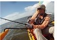
After the 4th of July weekend my son (13) and I drove up to Sea Level and camped at the Cedar Creek Camp Grounds. Our plan was to take 3 days to do a lap of the North Carolina Challenge course. I am planning to race it in Oct and I wanted to see the area; scout canals see what the course looked like before the event. Aside from the Start\Finish on Cedar Island we followed the race route.
We set off on Wed the 6th and by 11:30am Friday morning we had the boat on the trailer and had completed 87.3 miles. Here is a link of the GPX tracks. You might need to expand the Strava map to see all the tacks.
Detailed map of our route.
https://www.strava.com/activities/635009883Wed we left the camp site and went south into Nelson Bay and took the Salters Creek out into Long Bay. This was pretty uneventful since it was still early morning and what wind we did have was on our backs. We went up North Bay towards the Old Canal (Indian Canal) on the south side of Piney Island.
That was also pretty uneventful from the perspective of sailing/kayaking. There was a nice 12-15mph close reach by this point and we made good time.
There were non-stop military aircraft on the Piney Island. My son really got a kick out of that. We saw an F-15 dropping flares while we were in the canal. THAT is a sight to see! As we exited the canal and headed up Turnagain Bay we again had a nice beam reach. We were moving along at a good speed when we found or were found by a large pod of 15 or so dolphins. That was a nice and they were swimming within 20-30 feet of the boat. By this point the wind was starting to pick up a little more and I was starting to worry about our trip up the Neuse since it was going to be headwind.
As soon as we made our turn into the Neuse our trip went from a fun sightseeing day sail and became really hard work in strong conditions.
The winds were on our nose the remainder of the day and we had to make a lot of tacks to make any headway. We had to stay as close to the shore as we could. It’s super shallow for 100ish yards, and if we went very far off the shore the water was too rough. The wind was blowing low to mid 20s and the waves were growing 3-5ft and breaking with whitecaps. So we had to work the balance of shallows and sandbars against too strong of wind and waves as we moved away from the shoreline. The trip up the Neuse really was a hard fought day. I had planned on camping on Great Island Once we got there it was obvious that is was just marsh grass so we came back to the nice beach leading into Clubfoot Creek. We made camp there and were completely exhausted. The plan for the 2nd day was to go down the Harlow, through Beaufort, and down to Shackleford Banks. Best Laid plans...
Clubfoot Creek wasn't too bad. I was able to get a little help from the wind and tack my way for most of it. Once we got down to where it really narrows I missed the channel and we struck deep muck. I had my mirage drive in and it just sucked right into the black muck. I had to get off the boat so that it would float up and out of the mud. I instantly sank to my shins fast and was about knee deep in goo when I crawled back into the boat. I pulled my drive out and paddled back to deeper water. There was a moderate tide against us for the duration of the canal. Nothing major, but enough to slow us down. The biggest issue really was the heat. The heat index was 105. So we just pedaled from shady spot to shady spot and took our time. We stopped under each bridge for a little to enjoy the shade. Once we cleared the 3rd bridge I put the sail back up. As the tree cover ended we were able to get some help from the wind again. Once we dumped into the Newport River we had really strong winds all the way over towards the airport. It was a really fun, but a somewhat tricky crossing towards the airport because of the wave height. We were making great time on this stretch until I hit sand. I walked the boat about 1/4 mile back towards the channel, then we made our way back towards the new bridge and to into Beaufort. I pulled the mast down to get under the bridge at Beaufort. We went under the bridge on far left side and not through the main channel under the bridge. On the other side we put the mast back up and pedaled into a strong headwind. We stopped for ice cream in Beaufort but the place was closed. Who closed an Ice Cream shop in a tourist town in July? We got back in the boat and made our way through the end of Taylor creek. By this point the tide was running out (Coming into Taylor Creek) We had pretty much a tailwind in Talyor creek through Beaufort. The winds were very strong and the radio was full of chatter of people having problems towards Shackleford Banks. It sounded really rough over there and I didn't want to mess with that. I decided that we would go over to the small beach near the Harkers Island swing bridge. This wasn't a bad decision, but my route to it was. I should have continued in the main channel heading east across the estuary and then headed up when I approached Harkers Island. Instead I headed up and went through the marsh and oysterbeds. I had a strong tailwind pushing me up, a scary fast tide flow coming at me. There were some really large standing waves that we pushed over slowly. The channel is really narrow and there was little room to go around the standing waves because it was so shallow on either side. We had the TI buried deep into several of the waves when the bow would pop up and we'd start making forward progress again. I was steering using a paddle because it was too shallow to have the rudder down. That was the 1st place on the trip where I really was starting to feel like maybe I had bitten off more than I could chew. It was definitely outside my comfort zone, but we made it through.. And I know what NOT to do in the event unless the tide is higher. We set the tent up on the beach by the swing bridge.
Then the next bit of bad luck. The weather radio starts a severe thunderstorm warning for Beaufort County. It was calling for 60mph winds based on radar, expecting trees down, roof damage etc. Not a good time to be camped on a beach.
The wind was blowing south down the North River straight on us. I called my wife and had her check the radar maps. Luckily we had cell service here. It was one of the few places I could even get a call out. I couldn’t get data, only texts and voice calls. She said it looked like it was going to go just north of us. Luckily it did. Unluckily not by enough! It was a really long night. We tied the boat as far above the high tide line as we could. I was afraid that there would be a "higher" tide since the wind was pushing the water on to the beach where we were. A mini-storm surge. High tide was 1:20am I stayed awake and watched the boat, our tent and the tide line. The storm did go north of us. It hit primarily between Smyrna and Davis. We have a Eureka timberline 4, A frame style tent. 1 pole bent about 45 degrees, another was bent less and the ridge line pole was heavily bent in the storm. My rainfly tie outs on the water side were in water at the highest tide. (We couldn't get any higher because of marsh grass). The storm came through in 3 waves and rained for two of them. I was in my rain gear and sat in the corner where the buckled pole was to keep the tent up. Lots of wind, lightning, thunder and rain. Somehow or another my son slept through almost all of it.
I was up and moving the next morning (Friday) around 5:30. I moved the boat back to the water (now almost low tide) made breakfast and we hit the water around 7:00am. I was tired and done with NC at this point. We had 18-20 miles left to get back to Sea Level. We headed under the bridge and put the sail up. The wind was blowing on our backs NE and had the tide coming at us again. We hit 2 sand bars. I am still shocked at how shallow the entire area is. If you deviate from the main channel at lowish tide you will hit bottom. More fast flowing water and standing waves in a few spots but not nearly as bad as when we came through the marsh area the previous afternoon. The trip up Core Sound was beautiful. Just rolling along with a strong steady tailwind. It was almost perfect. We changed course a few times to avoid shallows but it was relaxing downwind sailing at 5-8mph. That was impressive because we had a strong tidal flow coming at us. I wish I knew what my water speed. Along with how shallow the area is I was surprised how fast the water was flowing through the tide changes. It really gets fast in a lot of sections.
All in all it was a great trip. It was a good scouting trip. I took way too much food, water, gear etc. The heat and weather made this trip difficult. I took some video that I am still going through to at some point I'll post it to youtube.
I’m looking forward to October!
Paul Links
Aero70