Return to Hobie.com
Hobie Forums
It is currently Mon Sep 08, 2025 4:40 pm

All times are UTC - 8 hours [ DST ]


Post new topic Reply to topic  [ 15 posts ] 
Author Message
PostPosted: Sat Apr 18, 2015 6:31 am 
Offline
Site Rank - Old Salt

Joined: Thu Jun 01, 2006 1:16 pm
Posts: 605
Location: Colorado
What I want.. but don’t think I can find.

On my old AI, when I got into shallow water the centerboard would kick up before there was any risk of the mirage drive flippers hitting the bottom. But.. on the TI, the centerboard depth is about the same as the flipper depth and I was being a little too careless recently (trained by the AI centerboard early warning) and bent the mirage drive masts on a sand bar.

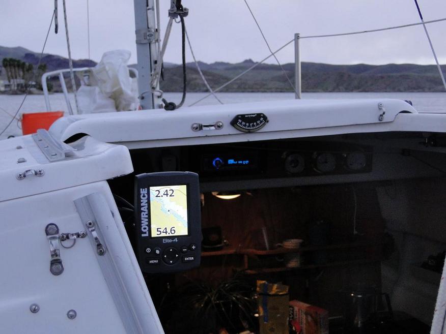
So the depth reading and alarm from a fish finder is now something I am considering. I have been using the Lowrance Elite 4 GPS fishfinder for several years now on a couple other sailboats and it almost meets my needs - but not completely. The picture below shows how I’m using it on my small sailboat. I mainly use it to show depth and my boat speed and it also shows my battery voltage.

Image

The map is nice to have once in a while but in the picture above, you can see how useless it is for how I normally use this boat. I think a lot of people put fishfinders on these boats because they are using the fishfinder for fishing. I never do this, my application is more of a speedometer that tells be depth.

After using the Lowrance Elite 4 for a while, there are two features that I wish it had.

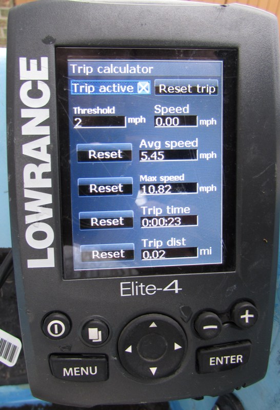
I partly bought this unit in the first place to tell me my peak speed after a sailing session. When your going balls out fast, it’s hard to look to the screen so I wanted the instrument to remember. However the 4 inch Elite does a really poor job at this. The GPS radio and software are prone to quick errors in location and this shows up as a big jump in speed but only for an instant. My sailing Dingy will hit over 7 knots but I often get peak readings of between 10 to 20 knots with the Lowrance Elite 4. One time I left it on for about 12 hours with the boat in the driveway and got a peak speed of over 20 knots - remember the boat was in the driveway all day. First time I had this happen I returned the unit thinking it was bad. The second unit did the same exact thing so I gave up and still have this second unit, just don’t use this peak trip speed function.

So.. I want an accurate peak speed reading. My hand held Garmin actually does do a good job at this so it’s possible. I don’t know if this is a better quality GPS radio or if it’s just better software for filtering out obviously bad speed readings..

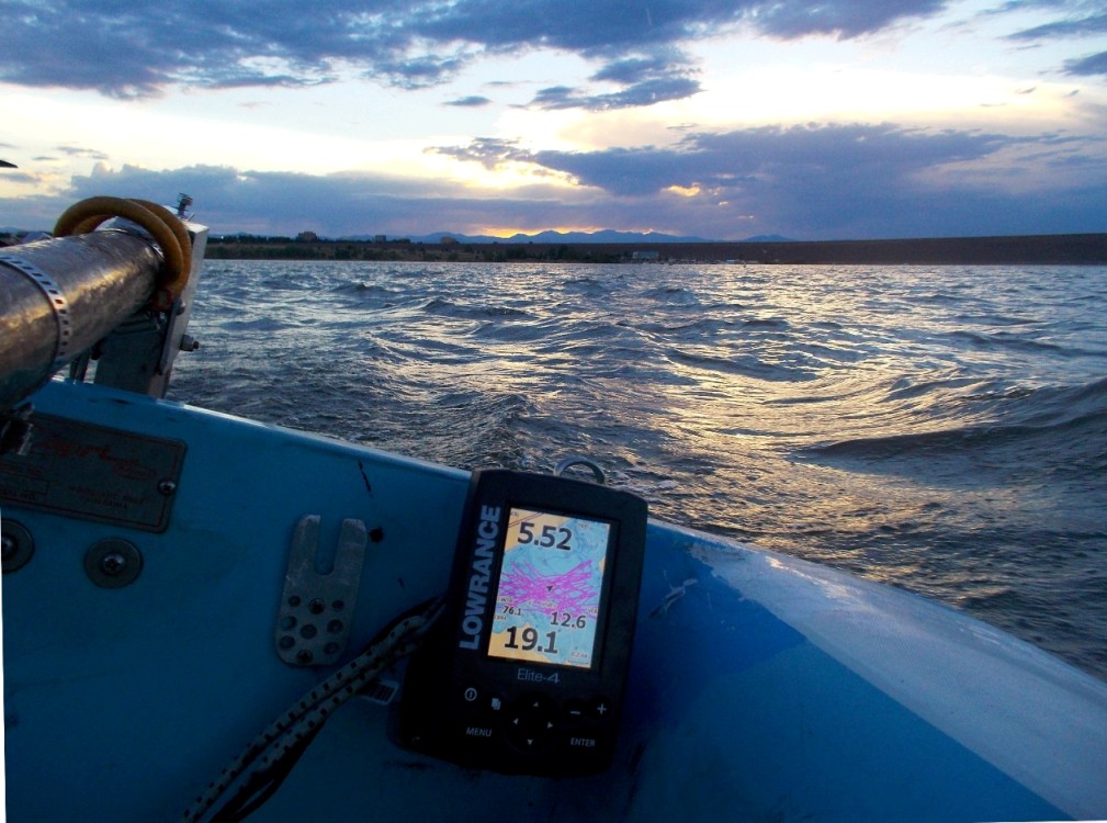
Second, the Elite 4 can have four different screens such as fish finder or maps or split. When I am just out sailing, I don’t need any of these screens and they just make the depth and speed numbers harder to read especially in bright sunlight. What I would like is a background that simply made the speed and depth numbers the easiest to read even in bright sunlight. I still like having the other screens (fishfinder and maps), just want one more that does nothing but make the numbers easier to see.

I still do like the Elite 4 depthfinder/GPS as the power consumption is very low (about .17 amps @ 12 volts in the map screen) and you can configure the display and lots of stuff can get displayed.. But I would really like this model if it had the two items above improved/ added.

The Garmin chart plotters probably do a good job at the peak speed reading but they have so many other features that I just don’t need (or want to pay for or to power – lots more current consumption).


Top
 Profile  
 
PostPosted: Sat Apr 18, 2015 10:22 am 
Offline
Site Rank - Old Salt

Joined: Sat Nov 05, 2011 1:58 am
Posts: 2893
Location: Forster, NSW, Australia
Walt, that speed peak issue sounds bizarre, but I also guess I would never need this readout. I have been using my Lowrance Elite 4 combo for nearly three years, and it works fine.

I think you would be better off showing the depth display behin the digital readouts you already have. Cycle through the various colour options until you find one where the bottom is easiest to read.

Now you can add to your digital readout by seeing the bottom ramping up as your primary indicator of depth. Because I sit in the front seat, and my transducer is in the rear cargo space scupper, seeing that trend is quite important!

_________________
Tony Stott
2012 Tandem Island "SIC EM" with Hobie spinnaker


Top
 Profile  
 
PostPosted: Sat Apr 18, 2015 11:09 am 
Offline
Site Rank - Old Salt

Joined: Thu Jun 01, 2006 1:16 pm
Posts: 605
Location: Colorado
I have had the false peak speed reading problem with actually three of these units. On that sailboat in the first picture I also tried moving the unit around to make absolutely sure that nothing was blocking the view to the sky either steady or transient - which didn’t fix the issue. Since you have the same unit, just try going into the trip setup screen, reset it (which resets the max speed), then leave the unit running for maybe half a day with the boat outside but not moving (or the other half of the day since you are on the other side of the planet). All three of the units I have had will give some whacked out peak speed readings. I have also seen the speed reading jump to some speed that was basically impossible for my boat while I was watching. The max speed remembers that bad reading. It seems to me that this problem could have been fixed by a software filter. I have always tested this in Colorado so over 5000 ft el.. I doubt elevation has anything to do with this.. but could not say for sure.

Yep, the depth transducer in the back is somewhat of a problem.. you just have to keep that in mind. Good idea to watch the ground slope! FYI, if you have measured the current draw of those units, the power goes up a fair amount when its showing the bottom vs. the map and its because the "ping" rate goes up a fair amount (you can hear this as well as measuring the current draw). On the other hand, this may not matter much. In the map mode, the color units use about 2 watts. In the fish finder mode, the unit uses about 3 watts.

I overall do like that unit. I have two of them, picture below is the other one

Image


Top
 Profile  
 
PostPosted: Sun Apr 19, 2015 7:19 am 
Offline
Site Rank - Old Salt

Joined: Thu Jun 01, 2006 1:16 pm
Posts: 605
Location: Colorado
Just to make sure I had not just seen some random thing in the past, I just left my Elite 4 on for about 8 hours with the boat in the driveway not moving.

The picture is of the trip screen

Image

You can see that the instrument recorded a peak speed of 10.82 mph. The threshold for recording any speed is 2 mph so the "noise" doesnt show up. The trip time was 23 seconds and the distance traveled was .02 miles (about 105 feet).

These are not expensive instruments so you cant expect it to be perfect.. It seems to me that a fairly simple software acceleration filter could have thrown this data point out?? Maybe a filter that I could set the thresholds for - such as a "sailing" mode.

Im also picking on a very small detail about this instrument. As I said earlier, I overall like it. But I dont trust any peak speed readings I ever get while out sailing.


Top
 Profile  
 
PostPosted: Sun Apr 19, 2015 9:05 am 
Offline
Site Rank - Old Salt

Joined: Sat Nov 05, 2011 1:58 am
Posts: 2893
Location: Forster, NSW, Australia
I can see how that is giving spurious readings.... I am also very impressed with the Navionics app, which cost under $20 from the Play Store. This is a good back-up, and I also like that I can save the track etc, and share it to my PC at home, where it automatically opens Google Earth, which is not possible with the Elite 4.
Image

_________________
Tony Stott
2012 Tandem Island "SIC EM" with Hobie spinnaker


Top
 Profile  
 
PostPosted: Sun Apr 19, 2015 9:51 am 
Offline
Site Rank - Old Salt

Joined: Thu Jun 01, 2006 1:16 pm
Posts: 605
Location: Colorado
those overlays are definatly cool! What are you using to collect the data points (and run Navionics)? Cell phone?

Hope your back on the water soon or already..


Top
 Profile  
 
PostPosted: Sun Apr 19, 2015 3:34 pm 
Offline
Site Rank - Admiral

Joined: Sat Aug 09, 2014 12:49 pm
Posts: 267
Location: Bethany, OK
You can get data from the Elite to Google Maps, though it's a bit convoluted. I do it with my Elite 5.

You put a micro-SD card in the unit (I have the Navionics card, just take it out, put in another to copy data to, then reinstall the Navionics card when finished) then go to the list of Tracks and save to the SD card.

On the computer use the program GPSBabel to convert the Lowrance file to Google's KML format. In the Options section of the input file check the box for "Break Segments Into Separate Tracks". This keeps any extraneous points from being part of the track on the lake. (Such as when I turn it on to export the data at home.)

Then just open the KML file in Google Earth. By default it shows the path and data points so it's kind of messy, you can turn off data points so only the path is shown on the map.


As for inaccurate GPS speeds, I've seen that on several different units.

My Elite 5 doesn't seem too bad overall, though I haven't tried logging max speed, but I did see it fluctuating some at slow speeds. When I was testing my drift chute it mostly showed 0.6-1.0 but every so often bounced up to 4.5 or so for a second.

I use a cycling app on my phone to track regular kayak outings and it also gets screwy at times. I once had it try to tell me I was doing 10 MPH with my Wind Paddle sail. Not a chance, the wind wasn't even that strong!

I also had a GPS unit in my car show - on a smooth stretch of highway - that I suddenly stopped for a bit then immediately accelerated to 150 MPH before settling back down to normal speed! :lol:


Edit: The program GPSBabel is here:
http://www.gpsbabel.org


Top
 Profile  
 
PostPosted: Sun Apr 19, 2015 6:00 pm 
Offline
Site Rank - Old Salt

Joined: Mon Jun 17, 2013 5:25 pm
Posts: 387
Location: Jaco, Costa Rica
I like that I can overlay the Navioncs over the Google Earth on my smartphone. On the water I just use the Navioncs boat map, works great for GPS and speed. Speed being the biggest for me, for surface fishing. Has it's drawback though, one, being the Samsung 3 smartphone I have does not show very brightly thru the waterproof pouch I carry it in. But the GPS speed is sufficiently visable. Also the batteries don't last long with the Navionics program running all the time. 3 hours max, so I carry 3 extra batteries. But then you have to take the phone out of it's water proof pouch and install another battery.
Otherwise the Lowrance locator is good, but not a very dependable device over time, seem not capable of handling the salt water/spray over time. I never get more than a couple months out of a unit. I think some kind of a cover to block out the spray is necessary. Anybody know where you can get such a cover for the Lowrance units? I've seen them in videos on yaks but have failed to find a place to purchase.

_________________
Mark
Tandem Island- 2013
2 - Sports - 2014


Top
 Profile  
 
PostPosted: Sun Apr 19, 2015 6:35 pm 
Offline
Site Rank - Old Salt

Joined: Sat Nov 05, 2011 1:58 am
Posts: 2893
Location: Forster, NSW, Australia
I agree that it is a shame that smartphone battery drain is the Achilles Heel compared to wired in fishfinder/chartplotter units.

I have experiented with different solutions to protect my sounder, and am happy with this plastic container. I cut out the front for good visibility of the screen, while a thin shock cord holds the lid on.
Image

_________________
Tony Stott
2012 Tandem Island "SIC EM" with Hobie spinnaker


Top
 Profile  
 
PostPosted: Sun Apr 19, 2015 6:54 pm 
Offline
Site Rank - Old Salt

Joined: Sat Nov 05, 2011 1:58 am
Posts: 2893
Location: Forster, NSW, Australia
walt wrote:
those overlays are definatly cool! What are you using to collect the data points (and run Navionics)? Cell phone?

Hope your back on the water soon or already..

It will still be a while before I can get back on the water, Walt, so for the present, I get my sailing jollies vicariously...

_________________
Tony Stott
2012 Tandem Island "SIC EM" with Hobie spinnaker


Top
 Profile  
 
PostPosted: Sun Apr 19, 2015 7:41 pm 
Offline
Site Rank - Old Salt

Joined: Mon Jun 17, 2013 5:25 pm
Posts: 387
Location: Jaco, Costa Rica
tonystott wrote:
I agree that it is a shame that smartphone battery drain is the Achilles Heel compared to wired in fishfinder/chartplotter units.

I have experiented with different solutions to protect my sounder, and am happy with this plastic container. I cut out the front for good visibility of the screen, while a thin shock cord holds the lid on.
Image


That cover looks good Tony, but these covers we're say Lowrance on them and wrap around the head unit with a plastic see thru screen. Can't find them for sale anywhere? Guess I should try calling Lowrance.

_________________
Mark
Tandem Island- 2013
2 - Sports - 2014


Top
 Profile  
 
PostPosted: Mon Apr 20, 2015 1:51 am 
Offline
Site Rank - Old Salt

Joined: Sat Nov 05, 2011 1:58 am
Posts: 2893
Location: Forster, NSW, Australia
The only "Lowrance" screen I have seen is solid white, and designed for use on an unattended boat.

_________________
Tony Stott
2012 Tandem Island "SIC EM" with Hobie spinnaker


Top
 Profile  
 
PostPosted: Mon Apr 20, 2015 3:29 am 
Offline
Site Rank - Admiral

Joined: Sat Aug 09, 2014 12:49 pm
Posts: 267
Location: Bethany, OK
CR Yaker wrote:
Otherwise the Lowrance locator is good, but not a very dependable device over time, seem not capable of handling the salt water/spray over time. I never get more than a couple months out of a unit. I think some kind of a cover to block out the spray is necessary.


Have you determined a point of entry for the water yet?

I've seen you and a couple others mention issues with the Lowrance units, had me a bit worried. I have mine mounted in just about the wettest place it can be, right beside the sail. It's regularly inundated while sailing fast. Of course I'm only in freshwater, which does make a difference.

One thing I wondered about is the external antenna connection, I lost that rubber push-on cap pretty quickly. It's possible that connector is waterproof even exposed but my experience from ham radio is that it isn't likely. Most of the waterproof connectors I've used were only that way when actually connected to the appropriate mating piece. Since I have no plan / need for an external antenna I just sealed mine well with a gob of silicone.

So far mine is still working fine...!


Top
 Profile  
 
PostPosted: Mon Apr 20, 2015 4:15 am 
Offline
Site Rank - Old Salt

Joined: Sat Nov 05, 2011 1:58 am
Posts: 2893
Location: Forster, NSW, Australia
Joe, do you have a ff/plotter combo, or just a fish finder? While the sockets on the rear are an obvious source of water ingress (and I found a suitable chair leg rubber stopper which fits over the spare socket beatifully), those models fitted with a micro SD card slot are hugely more susceptible to water problems. The supplied rubber cover is very difficult to fit effectively, so it them becomes necessary to cover the cover(!) with tape, and in my case, add the whole lot inside a plastic container.

_________________
Tony Stott
2012 Tandem Island "SIC EM" with Hobie spinnaker


Top
 Profile  
 
PostPosted: Mon Apr 20, 2015 1:52 pm 
Offline
Site Rank - Admiral

Joined: Sat Aug 09, 2014 12:49 pm
Posts: 267
Location: Bethany, OK
Mine is the ff/plotter combo. So far the rubber cover over the card slot has been dry underneath and snaps on pretty snugly but I can easily imagine it'd get loose over time - especially since I tend to open it up to swap cards and download trip data after each outing.

Perhaps part of my luck is that mine, sitting right beside the sail, is facing straight backward and angled a little up so even though it's inundated often the force of the water is against the back and not the side or front where the rubber cover is.


Top
 Profile  
 
Display posts from previous:  Sort by  
Post new topic Reply to topic  [ 15 posts ] 

All times are UTC - 8 hours [ DST ]


Who is online

Users browsing this forum: No registered users and 2 guests


You cannot post new topics in this forum
You cannot reply to topics in this forum
You cannot edit your posts in this forum
You cannot delete your posts in this forum

Jump to:  
© Hobie Cat Company. All rights reserved.
Powered by phpBB® Forum Software © phpBB Group