Return to Hobie.com
Hobie Forums
It is currently Fri Jul 18, 2025 10:26 am

All times are UTC - 8 hours [ DST ]


Post new topic Reply to topic  [ 18 posts ]  Go to page 1, 2  Next
Author Message
 Post subject: Same Ship- Different Day
PostPosted: Mon Jun 30, 2008 9:43 pm 
Offline
Site Rank - Old Salt

Joined: Thu Jul 27, 2006 4:50 pm
Posts: 494
Location: sacramento california
:x


Last edited by kepnutz on Tue Sep 16, 2008 3:54 pm, edited 2 times in total.

Top
 Profile  
 
 Post subject:
PostPosted: Tue Jul 01, 2008 2:27 pm 
Offline
Site Rank - Captain

Joined: Mon Jun 19, 2006 5:37 pm
Posts: 47
Location: Folsom, CA; Lake Tahoe, CA
Nice pics Kep. I hope to try T-Bay sometime as the inland lakes dry up. Your pictures and documentary really give me an idea of what to expect and may help alleviate my wife's concerns about it. Can you give me a few tips?

Best place to launch and park? (we have out two Adventures on a trailer that we need to consider when parking in a crowded area).

Which direction to travel for the sandy beaches, while minimizing the currents?

Anything else you can think of would be appreciated.


Top
 Profile  
 
 Post subject:
PostPosted: Tue Jul 01, 2008 9:53 pm 
Offline
Site Rank - Old Salt

Joined: Thu Jul 27, 2006 4:50 pm
Posts: 494
Location: sacramento california
Hi Ya Ref :)
:!:


Last edited by kepnutz on Tue Sep 16, 2008 3:55 pm, edited 1 time in total.

Top
 Profile  
 
 Post subject:
PostPosted: Wed Jul 02, 2008 9:04 pm 
Offline
Site Rank - Captain

Joined: Mon Jun 19, 2006 5:37 pm
Posts: 47
Location: Folsom, CA; Lake Tahoe, CA
Thanks Kep. Lots of great info -- better than what I have seen in any books or anywhere else on the web. Thanks Again!!!!


Top
 Profile  
 
 Post subject:
PostPosted: Wed Jul 02, 2008 10:12 pm 
Offline
Site Rank - Old Salt

Joined: Thu Jul 27, 2006 4:50 pm
Posts: 494
Location: sacramento california
Hey Ya Ref
Kepnutz


Last edited by kepnutz on Tue Sep 16, 2008 3:55 pm, edited 1 time in total.

Top
 Profile  
 
 Post subject:
PostPosted: Sat Jul 05, 2008 4:08 pm 
Offline
Site Rank - Old Salt

Joined: Thu Aug 16, 2007 2:25 pm
Posts: 2866
Location: Central Coast NSW Australia
G'Day Kep,
Enjoyed reading both your posts. Excellent pics as usual. 8) Looks like a great trip. Interesting to see the different vegetation to what we are used to here (no gum trees)!


Top
 Profile  
 
 Post subject:
PostPosted: Sun Jul 06, 2008 6:53 am 
Offline
Site Rank - Old Salt

Joined: Thu Jul 27, 2006 4:50 pm
Posts: 494
Location: sacramento california
G'day Stringy :D
:!:


Last edited by kepnutz on Tue Sep 16, 2008 3:56 pm, edited 1 time in total.

Top
 Profile  
 
 Post subject:
PostPosted: Mon Jul 07, 2008 8:21 am 
Offline
Site Rank - Old Salt

Joined: Fri Nov 19, 2004 6:56 am
Posts: 822
Location: Tallahassee, FL
Hey Kep & Crew,
Great tale and pics as usual! As an interesting side note, Tomales Bay is one of the classic examples of a fault-formed bay since it lies right on top of the San Andreas Fault. Thus, if you camp on the west side of the Bay you are residing on the great Pacific Plate. But, if you camp on the east side of the Bay you are hanging out on the North American Plate--pretty cool! Same with Bodega Bay just to the north. In fact the rocks on Bodega Head used to be attached to the California Coast far to the south, somewhere in the vicinity of Santa Barbara, as was probably the case for the land on the west side of T-Bay. Here's a pic with Bodega Bay in the foreground and T-Bay in the distance.

Image

_________________
Image


Top
 Profile  
 
 Post subject:
PostPosted: Mon Jul 07, 2008 2:10 pm 
Offline
Site Rank - Old Salt

Joined: Thu Jul 27, 2006 4:50 pm
Posts: 494
Location: sacramento california
Hey Apalach
Thanks for the photo of the bay its really cool.
Kepnutz


Last edited by kepnutz on Mon Jul 07, 2008 9:20 pm, edited 1 time in total.

Top
 Profile  
 
 Post subject:
PostPosted: Mon Jul 07, 2008 9:16 pm 
Offline
Site Rank - Old Salt

Joined: Thu Jul 27, 2006 4:50 pm
Posts: 494
Location: sacramento california
How Ya Going Apalach :D
:?: :arrow:


Last edited by kepnutz on Tue Sep 16, 2008 3:56 pm, edited 1 time in total.

Top
 Profile  
 
 Post subject:
PostPosted: Tue Jul 08, 2008 11:26 am 
Offline
Site Rank - Old Salt

Joined: Fri Nov 19, 2004 6:56 am
Posts: 822
Location: Tallahassee, FL
Yep Kep,
One of my favorite UG courses at Stanford was Historical Geology. Then, each time I drove home to LA for spring break or Christmas I would take detours to see the exact geological features we had been hearing about in class--pretty neat!

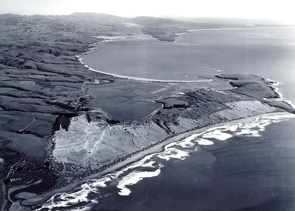
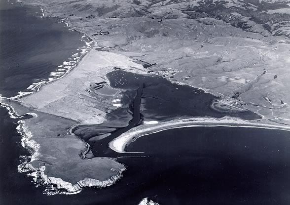
What always fascinated me about Bodega Head is how the Head looks like it has been sliced off the mainland with a giant knife along its inboard side--and in fact that is pretty much what has happened along the San Andreas. Then as the Head moved out to sea, firmly attached to the Pacific Plate, the longshore currents filled in the gap between the Head and the mainland with deposited sand to form a classic marine geological feature known as a tombolo. You can clearly see that in the first pic above and in the one below where we are looking north along the coast. Based on current Pacific plate movement, it is expected that LA will be opposite San Francisco in abut 50 million years or so! Eventual cross-town rivals in at least baseball, dontcha know!

Image

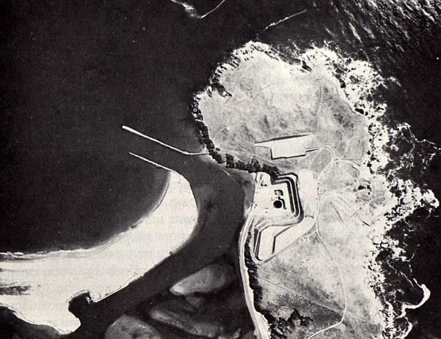
Of course, we now have the rather infamous feature on Bodega Head known as the "hole in the Head," where P.G.&E. began digging the reactor pit for their proposed nuclear power plant. It is now well-fenced-off and used to be rented to Sonoma County for $1.00/year, just in case PG&E ever got the go-ahead to build again. Fortunately, one of PG&E's own geologists could not agree that the rather jumbled rock along the Fault was stable enough on which to build a nuclear reactor right on the San Andreas itself, and the whole project was finally shelved!

Image

As I recall, PG&E had planned for a maximum vertical movement of something like 7-12 feet. However, during the great Good Friday quake off Alaska in 1964 we had vertical movements along the coast of over 20 feet in places! And the prevailing winds at Bodega are such that the radioactive cloud from any kind of rupture would be over S.F. in about an hour or so! You can imagine the fun and games in trying to evacuate S.F. across the bridges and down the Peninsula. It's already a madhouse during rush hour!!

_________________
Image


Top
 Profile  
 
 Post subject:
PostPosted: Tue Jul 08, 2008 1:52 pm 
Offline
Site Rank - Old Salt

Joined: Mon Jul 16, 2007 7:58 pm
Posts: 429
Location: Indianapolis, IN
You know, even in those long distance pictures, it sure seems like there are a lot of BIRDS in Bodega Bay! :shock:

I have an uncle-in-law who taught elementary school in Bodega, but not at the famous school-house on the hill.

_________________
What - Me Worry?


2006 Hobie Wave 7358
"Ish Kabibble"


Top
 Profile  
 
 Post subject:
PostPosted: Tue Jul 08, 2008 6:20 pm 
Offline
Site Rank - Old Salt

Joined: Thu Jul 27, 2006 4:50 pm
Posts: 494
Location: sacramento california
Hey Apalach Hi Indy
:x :cry: :?: :!: :shock: :( :twisted:
Kepnutz


Last edited by kepnutz on Tue Sep 16, 2008 3:57 pm, edited 1 time in total.

Top
 Profile  
 
 Post subject:
PostPosted: Tue Jul 08, 2008 7:10 pm 
Offline
Site Rank - Old Salt

Joined: Fri Nov 19, 2004 6:56 am
Posts: 822
Location: Tallahassee, FL
Yep Kep,
Wow--great pic. Interestingly enough, the house that Hitchcock had built, and in and around which the "Birds" was filmed, was still on the Bodega Marine Lab property right next to the old road to the Lab when I first started working there. In fact, you can see Horseshoe Cove and BML at the upper right in your pic. Brings back a lot of memories, including hanging out at the Tides. I also used to camp out in the dunes on Doran Spit before it became a park. Just put the ole Land-Rover in 4WD low and chugged on out there--no camp sites, no RVs, no cars, no people, no restrictions, and no one to hassle you back in those days.

I've often thought about yaking in B-Bay also, but I think for the variety of diverse habitats and general scenery, T-Bay probably has it beat. Also interesting is the freshwater seep coming out of the hill side about in the center of your pic. Some of the old records indicated that was one of the few places where the early day fur traders and explorers were able to put in and fill their casks with fresh water.

_________________
Image


Top
 Profile  
 
 Post subject:
PostPosted: Tue Jul 08, 2008 8:57 pm 
Offline
Site Rank - Old Salt

Joined: Thu Jul 27, 2006 4:50 pm
Posts: 494
Location: sacramento california
Hey Apalach.
Kepnutz :cry: :? :lol: 8) :shock: :) :o :D :roll: :wink: :idea: :arrow: :wink:


Last edited by kepnutz on Tue Sep 16, 2008 3:57 pm, edited 1 time in total.

Top
 Profile  
 
Display posts from previous:  Sort by  
Post new topic Reply to topic  [ 18 posts ]  Go to page 1, 2  Next

All times are UTC - 8 hours [ DST ]


Who is online

Users browsing this forum: No registered users and 2 guests


You cannot post new topics in this forum
You cannot reply to topics in this forum
You cannot edit your posts in this forum
You cannot delete your posts in this forum

Jump to:  
© Hobie Cat Company. All rights reserved.
Powered by phpBB® Forum Software © phpBB Group